
The official definition of a food desert is a low income census tract where at least a third of the residents are a mile from a supermarket or large grocery store. Those criteria imply that they are have limited access to fresh, whole, nutritious food and may not be able to afford it, if they can get it.
By applying these criteria, the USDA Food Desert Locator highlights those census tracts that are considered food deserts.
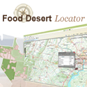
Do you know which parts of your city comprise food desserts? Here’s a map of southern Seattle showing the location of the food deserts in the city.

Mapping tools like this are extremely useful for urban planners, policy makers, and businesses who need to know where the opportunities for improvement lie.
Users can scan the map and zoom into an area or use the search feature to find a specific location. Users can create maps showing food desert census tracts. They can also view and download statistics on population characteristics of a selected tract—e.g., the percentage and number of people that are low income and have low access to large grocery outlets, or the number of “low-access” households without a car.
The Food Desert Locator can be used in conjunction with the recently updated Food Environment Atlas, which presents a broad set of statistics on food choices, health and well-being, and community characteristics. The Atlas presents data at the county level, while the new Food Desert Locator data are at the census tract level, covering smaller subdivisions whose general population characteristics are often relatively homogeneous.